Water-associated Diseases Working Group journal article
Members of the GEO Blue Planet Water-associated diseases working group along with partners from Plymouth Marine Laboratory, National Centre for Earth Observation (NCEO), Council of Scientific and Industrial Research (CSIR)-National Institute of Oceanography (NIO), Indian Council of Agricultural Research (ICAR)-Central Marine Fisheries Research Institute (CMFRI) and Nansen Environmental Research Centre India (NERCI) have published a new journal article in Remote Sensing titled “Environmental Reservoirs of Vibrio cholerae: Challenges and Opportunities for Ocean-Color Remote Sensing”
Abstract
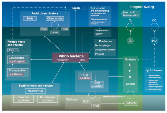
The World Health Organization has estimated the burden of the on-going pandemic of cholera at 1.3 to 4 million cases per year worldwide in 2016, and a doubling of case-fatality-rate to 1.8% in 2016 from 0.8% in 2015. The disease cholera is caused by the bacterium Vibrio cholerae that can be found in environmental reservoirs, living either in free planktonic form or in association with host organisms, non-living particulate matter or in the sediment, and participating in various biogeochemical cycles. An increasing number of epidemiological studies are using land- and water-based remote-sensing observations for monitoring, surveillance, or risk mapping of Vibrio pathogens and cholera outbreaks. Although the Vibrio pathogens cannot be sensed directly by satellite sensors, remotely-sensed data can be used to infer their presence. Here, we review the use of ocean-color remote-sensing data, in conjunction with information on the ecology of the pathogen, to map its distribution and forecast risk of disease occurrence. Finally, we assess how satellite-based information on cholera may help support the Sustainable Development Goals and targets on Health (Goal 3), Water Quality (Goal 6), Climate (Goal 13), and Life Below Water (Goal 14).